Fertilizing with the drone

Agriculture constantly has to adapt to real-world changes in climate and weather. This year has been particularly wet so far, making it almost impossible for traditional farming machinery to move on the field. Wet and muddy conditions prevent the fertilizing of the fields and therefore present a real threat to the potential yield. Traditionally, fertilizing would have to be pushed far back into the season to wait for better conditions, so farmers are looking for alternatives.

In those conditions, a drone can come in handy as it is not affected by the conditions of the soil. Here the challenge lies in the high application rates, more than 100 kg per hectare. Join us on our journey as we help the Havellandhof, a farm close to the German village Ribbeck. Together with the Institute of Agricultural and Urban Ecological Projects (IASP), we are doing nitrogen fertilization on one of Havellandhof’s fields. We will show you through this challenge, showcasing the preparation and the execution of the mission, and later talk about a few key learnings that we had during our mission.
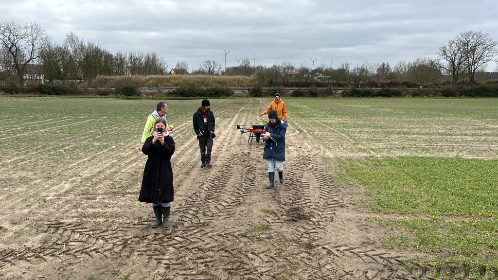
Preparation

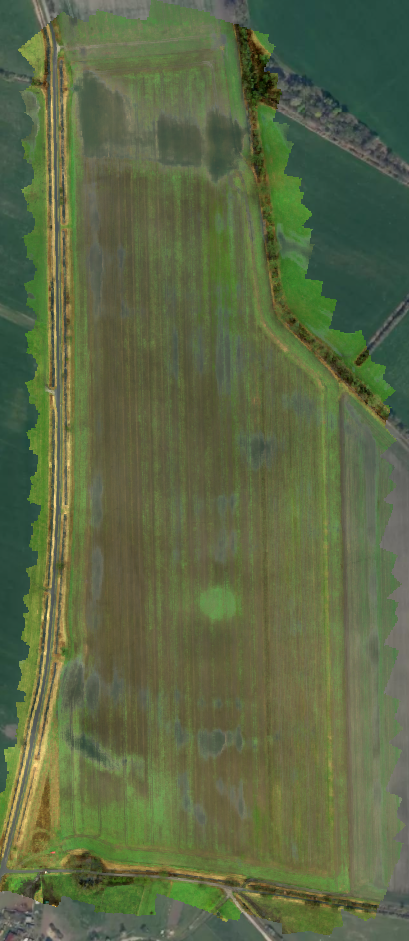
As for any big challenge, preparation is the key to efficient drone operation, regardless of mission type. The first step in the planning was to make an orthomosaic of the field with a mapping drone. The field has a size of around 27 ha. The mapping of the field and generation of the map took around one hour. With the field mapped, we were able to identify puddles, cultivated areas, and areas where plants have not been able to grow. This information is necessary to determine the flight path of the drone during the fertilization process. For example, the application of fertilizer in the puddles was not wanted, so we planned ahead accordingly by modifying the flight path of the drone around the puddles. This flexibility is one of the key strengths of the drone.

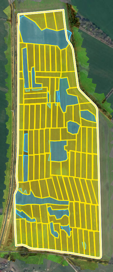
The next step was to divide the field into manageable polygons. The key goal for the division was to minimize the distance flown without application or with an empty tank. Therefore, a couple of parameters had to be determined:

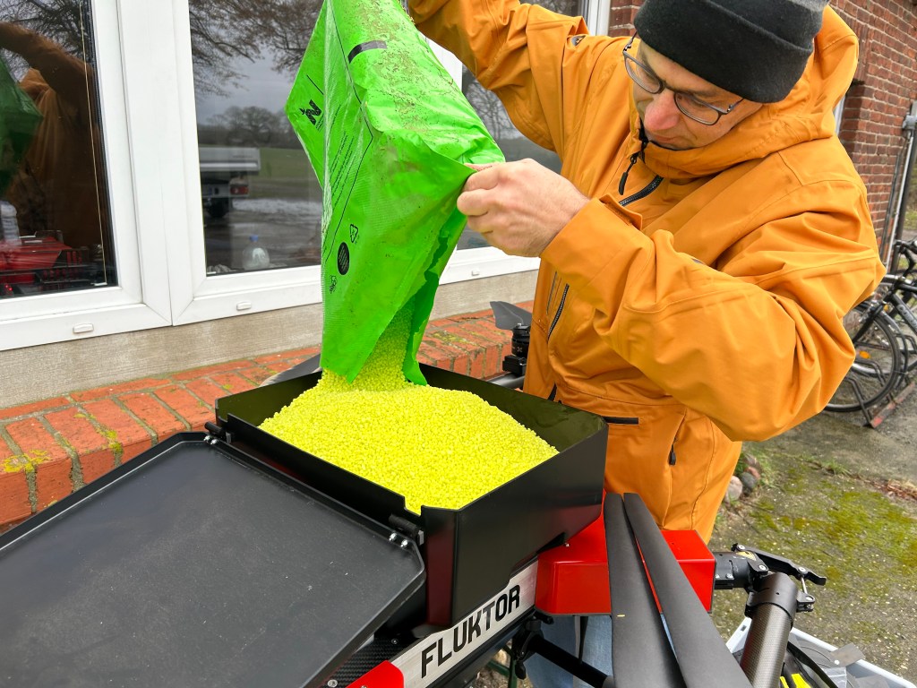
  • Application rate: This is the most important parameter for any spreading mission as it is the limiter for most other parameters such as polygon size, flight speed during application, or necessary volume flow. It also serves as a baseline to determine all other parameters. For this mission, our goal application rate was 60 kg of nitrogen per hectare. The fertilizer itself has 46% nitrogen, bringing the total application rate to 125 kg of fertilizer per hectare.
  • Tank volume: This parameter influences the size of each polygon. The tank of the CS50 drone holds up to 30 l volume. For this fertilizer, it meant that we could comfortably carry 25 kg of fertilizer per flight. Together with the application rate we can now determine the size of each individual polygon to be 0.2 hectares.
  • Flow rate: With this parameter, we are able to calculate the horizontal flight velocity for each polygon. To find it we filled up the tank of the drone with fertilizer and ran the dosing shaft for 90 sec. We then measured the total weight of fertilizer that was pushed out by the dosing shaft at that time. This gave us a flow of 85 grams of fertilizer per second. Together with the size of the polygons we can now determine the flight velocity to be around 0.7 meters per second.
  • Polygon shape: Lastly we needed to define the overall shape of each polygon. Again, the goal was to minimize the number of flights without application or with an empty tank. This means keeping the starting point and the endpoint of each mission as close to the takeoff point as possible and only using a turnaround when necessary. Under these circumstances, the best shape was a polygon with a rectangular shape and dimensions of 20 meters by 100 meters.

With all those predetermined parameters it was time to cut the field into the segments. This worked mostly but due to the puddles, and the overall shape of the field, it was not always possible. In these cases, the polygon shape was changed to fit the circumstances while keeping the size at around 0.2 hectares. This way we could ensure that the mass of fertilizer would be sufficient for each polygon.

Execution

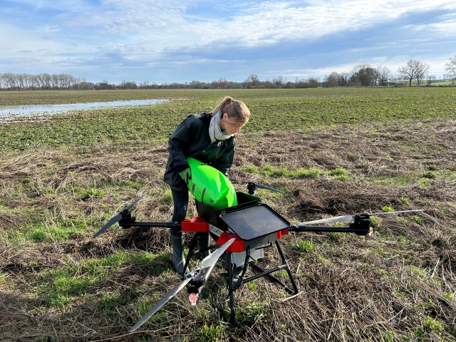
With the preparations done, it was time to move on to the execution. The day of the execution promised nice weather with low wind conditions which made it ideal to to fly the drone and spread the fertilizer. We loaded up the car and made our way to the field. Since we had made a good plan it was simply a matter of filling the tank, loading the path onto the drone, and executing the mission. The groundwork was split into two positions. One person was refilling the tank and checking the batteries, while the other person was responsible for the piloting. This way our ground times have been around 2 minutes per mission.

Here’s what a typical flight looked like:

  • First, the tank was filled and the remaining battery capacity was checked. If the battery capacity was not sufficient enough for the next flight, the battery was changed to a full one.
  • During filling the pilot loaded the next mission into the Fluktor app and checked the settings.
  • Once all settings were confirmed and the drone was ready to go, the pilot took off manually and flew to the starting point of the mission.
  • Then the mission was started within the Fluktor App. The drone executed the mission fully autonomously.
  • Once the mission was finished the pilot took over the sticks again to fly the drone back to the car for refilling and a potential battery change.

To charge the batteries in the field, we utilized a petrol generator. The generator had enough power to simultaneously charge two batteries. This meant that we could ensure continuous operation with two chargers and six batteries. During our first flight, we were able to cover an area of 3.2 hectares in three hours. During those three hours, we had a total of two hours of flight time and one hour of ground time.

Key Learnings

During these first tests, we learned a lot to improve the system and also the workflow. The first thing we learned is that preparation is key. This is especially true for the planning of the individual missions as it would take some time in the field to adjust them. This can lead to small inefficiencies that could, over time, lead to less area coverage at the same time. Secondly, we learned that it is much faster to fly the drone manually to the starting point of the mission. This is due to a higher velocity that can be reached in manual flight. This also applies to the return back to the pilot.

We have also learned that the dosing shaft is not big enough for these high application volumes. It would be better to increase the volume flow. If the volume flow were higher, we could fly faster during the missions. This change can already be made due to the versatility of the Lehner FlyDos Spreading unit. We can change the shaft to one with bigger cell wheels, increasing our volume flow. This would lead to an overall increased efficiency. First tests with bigger cell wheels showed an increased volume flow from 85g/s up to 200g/s, almost tripling the flow.

We have now implemented our key learnings for our next tests to see the improvements we can yield. Stay tuned for updates on this matter in the next few weeks.

Experiment on spreading width on the IASP site

The results of the application were published in the online edition of agrarheute on 28 February 2024.

Altitude control in viticulture

In defiance of inclement weather conditions, we conducted tests last week addressing the challenge of precise altitude control in uneven terrain. The drone’s altitude above ground directly influences the working width and the dispersion of spray mist, penetrating foliage with precision, an aspect crucial in agricultural applications.

Fluktor pursues an innovative approach by incorporating detailed elevation data into the flight planning process. In this methodology, distance sensors serve solely for collision avoidance. When the „calculate above ground“ option is selected in mission planning, a flight path is computed with a relative distance to the ground profile. Elevation data is sourced through an internet service utilizing satellite data, with a resolution typically around 30 meters per pixel, sufficient for moderately undulating terrains with sparse vegetation. However, when accounting for bushes, trees, rocks, or steep inclines, especially during low-altitude flights, we recommend employing photogrammetric height profiling before mission planning and execution.

The procedure involves flying a photo drone at an altitude of approximately 70 to 120 meters, capturing images, and processing them reliably with tools like Pix4DCapture and Pix4DFields. The subsequent generation of a high-resolution orthomosaic and surface model yields profile data with a resolution typically in the centimeter range. This elevation profile can be exported from Pix4DFields and seamlessly integrated into the flight planning software. The resolution disparity is visible in the video at 0:42 minutes compared to 0:37 minutes, showcasing the precision of the photogrammetric assessment in detecting field vegetation height, trees, and bushes.

Our tests were conducted at relatively low speeds of 2.5 m/s and altitudes of 10 meters and 5 meters, with the mission planning algorithm calculating intermediate points at varying altitudes for the drone to traverse. Satisfied with the results of these tests in viticulture, the drone maintained the pre-planned altitude with impeccable precision. Further experimentation awaits us, adjusting ascent speed and the number of intermediate points to ensure a uniformly controlled flight. As we progress into spring, our focus will shift to spreading and spraying trials in the same terrain. We want to thank Weinbau Rapp near Halle for allowing us to conduct these tests.

Tests in viticulture

Cinque Terre

Wir haben so viel vor.
Anne, steh‘ auf und lieg‘ nicht faul auf dem Ohr!
Wir essen schnell Frühstück im Dunkeln.
Am Himmel die Sterne noch funkeln,
denn wir haben keine Zeit.
Zum Zug nach Cinque Terre. Es eilt.

Cinque Terre – das sind fünf Orte mit bunten Häuschen
dicht gedrängt am Fels. Und Cafés, die laden ein zum Päuschen.
In der Mitte die alte Kirche so pompös.
Die Bewohner sind streng religiös.
Die Touristen stehen am Hafen und posen und zeigen das schönste Insta Smile.
Ich fühle mich zu Hause. Hier ist die Welt noch heil.

Wir wandern von Ort zu Ort über rauhen, steilen Stein.
Der Weg ist weit. Man spürt’s im Bein.
Rechts das Meer und links der Olivenhain.
Unterwegs ein schönes Café
mit vielen Likes im WWW.
Der Orangensaft ist frischgepresst. Und dazu Tee.

Wir steigen auf’s Boot.
Von Riomaggiore zurück entlang der Küste im Abendrot.
In Levanto hole ich mir eine Cola am Automat
auf dem Bahnsteig. Wir nehmen den Zug für die Rückfahrt.
In einer Bar gibt’s noch Wein
mit Chips und Oliven. Wer sagt da schon nein?

Viel vor hatten wir.
Jetzt gibt’s aber noch ein Bier.
Alles, was gesagt war
ist auch wahr 😉
Ich sage Ciao
for now.

Und gehe jetzt offline.

Portofino

Es fühlt sich so an, als würden wir schon immer im Auto leben. Alles hat jetzt seinen Platz gefunden. Alles fügt sich. Die Sonne kommt früh langsam herum und taucht den alten Steinbruch, in dem der Campingplatz liegt, ins Morgenlicht.

Wir fahren mit der Bahn nach Santa Magherita. Der Weg führt an Rapallo vorbei, dem Ort in dem Walter Rathenau den Rapallo-Vertrag mit der Sowjetunion im Jahre 1922 aushandelte. Von Santa Mageritha nehmen wir den Bus nach Portofino. Überall sind Touristen. Wir folgen dem schmalen Weg zur Kirche Chiesa di San Giorgio. Die Kirche hat überregionale Bedeutung erlangt für die Skulptur der Jungfrau Maria mit dem Jesuskinde im Arme, die die Bitte eines Schafhirten empfängt. Die Szene spielt offenbar im Winter wegen des Schnees. Wir können nur mutmaßen, um was es ging. Man weiß es nicht mehr. Vielleicht bat der Hirte um Futter für seine Tiere.

Die Bar am Faro di Portofino bietet eine großartige Aussicht und super Cocktails. Abends dann zurück nach Siestri Levante und Altstadt ansehen.

Abenga und Genua

Auf dem Weg nach Sistre Levante machen wir einen ersten Zwischenstopp in Abenga. Der Ort hat eine schöne, gut erhaltenen Altstadt. Die Gassen sind eng und dunkel, die Häuser klein. Man sagt ja, die Menschen seien früher kleiner gewesen als heute. Das muss wohl hier auch so gewesen sein. In der Stadt gibt es hochaufragende sogenannte Geschlechtertürme. Diese Türme erheben sich in frevelhafter Weise höher als die Glockentürme der Kirchen und zeugen vom Reichtum der damaligen adligen Familien.

Der nächste Stopp ist in Genua. Unten am Hafen ist ein buntes Treiben der Händler und Spielleute. Sofort umringen uns Kinder. Gut, dass wir immer ein paar Glasperlen in der Tasche haben. Am Kai liegt die Galeere Neptun, mit der sich die Einheimischen auf das Meer wagen. Überall kleine, lästige Fliegen, die uns umschwirren. Anne hat Hunger und will sich ein Fladenbrot aus Kichererbsenmehl kaufen. Wir finden aber den Laden nicht.

Per Rad von Imperia nach Sanremo

Wir leihen uns Fahrräder in Imperia und fahren auf einer ehemaligen Bahnstrecke nach Sanremo. Die Strecke ist heute asphaltiert und steht ausschließlich Radfahrern, Fußgängern und Skatern zur Verfügung. Es geht vorbei an der felsigen Küste, durch lange, dunkle Tunnel, durch die Innenstädte von Port-Maurice und Bussana und entlang schöner Sandstrände. Am Wegesrand warten Cafés auf Gäste. Wir sehen uns den Hafen von Sanremo an, gehen dann baden und liegen am Strand.

Morgen geht’s nach Siestri Levante.

Èze und Nizza

Wir verbringen zwei Tage an der Cote d’Azur und übernachten in Èze, einem hübschen, kleinen Ort unweit von Nizza. Oben auf dem Berg, wo einst eine Burg stand, findet sich oberhalb der engen Altstadt ein botanischer Garten. Man sieht dort neben Blüten, Kakteen, Sukkulenten und Aloe Vera auch Besucher aus aller Welt. Französinnen und Italienerinnen tragen Kleider. Die Deutschen bevorzugen Sportives in Goretex und Softshell.

In Nizza ist heute Markttag. Es dauert gar nicht lange und wir tragen Tüten mit allerlei Mitbringselgeschenken mit uns. Wir trinken Kaffee und essen Socca, ein Gericht aus Kichererbsen, in den Gassen der Altstadt. Dann liegen wir noch faul am Strand rum.

Auf der Autobahn

Es geht Richtung Süden auf der Autobahn.
Die Sonne scheint. Es ist warm.
Das Ziel der Fahrt dieses Tages ist Dinkelsbühl.
Als wir ankommen, ist es dunkel und schon kühl.
Häuser dicht gedrängt, umgeben von Türmen und Maur‘.
Von oben die Wächter mit Stundgeschrei rauh.
Oder ist es doch der Sünder im Schandholz?
Wir gehen ins Weib’s Brauhaus, was sollt’s.
Hähnchen und Bratkartoffeln bekommt die Anne
aus der Pfanne.
Die Kinderzeche wird hier gefeiert jedes Jahr,
die die Stadt vor der Zerstörung bewahr‘.
Am Morgen gibt es dann Frühstück mit Brötchen und Ei.
Anne sagt, Christiane grüsst aus der Mongolei.
Und es geht wieder Richtung Süden auf der Autobahn.

Some recordings

Henrik Battke (tb) + iReal Pro – Body and Soul / John Green, Edward Heyman, Robert Sour, Frank Eyton
Henrik Battke (tb) + iReal Pro – Just Friends / Sam M. Lewis, John Klenner
Henrik Battke (tb) + iReal Pro – All The Things You Are / Jerome Kern, Oscar Hammerstein
Henrik Battke (tb) + iReal Pro – Doxy / Sonny Rollins