
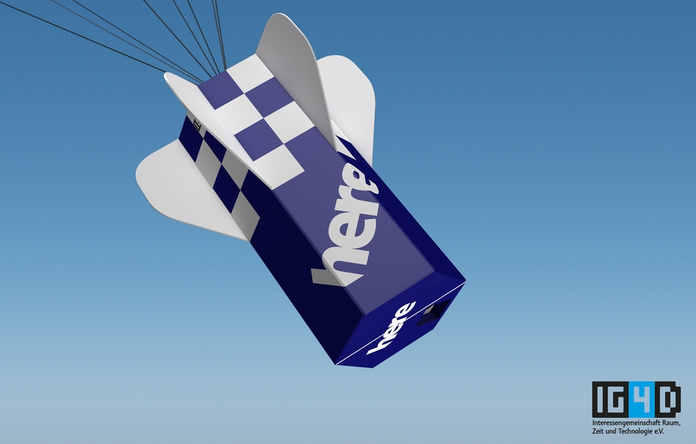
Based on the idea to create a video from a space dive the team around IG4D started to kickoff this project, even before the famous “Baumgartner jump”. Investigations showed quite quickly, we can make it. Most of the stuff we needed could be either bought or manufactured, so let’s go. The plan sounded easy – use a weather balloon to lift up a transport capsule to 100,000ft (30km). At this level the outbound pressure is close to zero, so the balloon will explode and fall down. At 7,000-10,000ft (2-3km) a parachute will open and help to land safety. In order to find the capsule after landing easily, we used a smartphone and it’s inbuilt positioning system to send an SMS of the current position once available.
Tool time
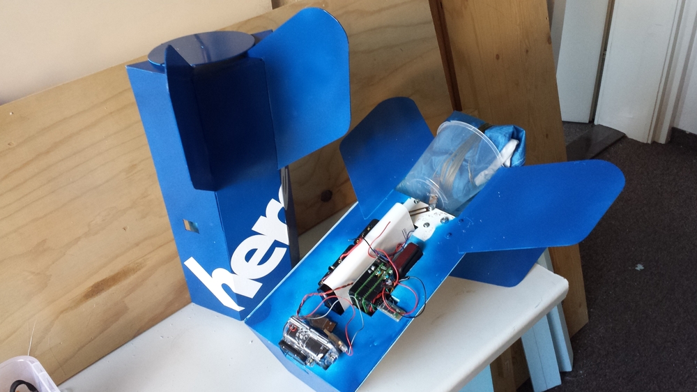
We started creating a parachute with a diameter of around 4ft (1.2m), capable of throttling a 3lbs (1.5kg) heavy transport shell. For the control unit we used a typical smartphone, a Samsung S2 in our case. This device is balance well between battery lifetime, camera quality (8MP) and weight. It turned out we needed some more sensors in order to operate reliably in space. Therefore we added an Arduino module capable of measuring air pressure, temperature and acceleration. The idea was, that once parameter tell the time is right, the Arduino will activate a motor controlled relays which then will open the parachute. Bluetooth network was the favorite choice to realize the communication between the systems. You will find the software listing here.
Battery life is really critical for every autonomous entity, no exception to our project. As the device display usually consumes most of the energy, we wrote the software in a way to only power the screens once we taking pictures. This leads to a 12hour lifetime without any extra battery pack. If you try to build with affordable components as we did, be aware of sometimes awkward issues. We used a typical Bluetooth communication module HC-05 / HC-06 from a Chinese manufacture, such as this one. It is shipped with various firmware versions, all slightly different. Finding out the right settings, e.g. baud rate, is a nice and mind-cracking way of wasting time. Finally we found a set of parameters which turned out to work very reliably. All of the flight control related input was gathered and processed within the smartphone controller app. Air pressure and acceleration data together with time information were mapped into certain flight phases, such as rise and fall. As said before, we planned to open the parachute using 2 relays. Therefore we tried to use a TB6612FNG motor control. We realized in the very last minute, that this configuration demanded a lot of power, which is a serious issue for batteries flying several hours in a sub zero °C environment. Finally we simplified the parachute opening mechanism to the bare minimum. In order to get our shell into space we bought a Pawan CPR 1200 weather balloon from ebay, which is guaranteeing to lift a 2lbs entity up to 100,000ft (30km). We filled the balloon with Helium. We lent a steal cylinder full of it from a local company. Thanks to Peter Lindner GmbH for sharing the valves. From our main sponsor HERE we were provided with an additional GoPro outdoor camera. Furthermore we integrated a redundant GPS / GSM positioning system, such as this one from ebay. Everything was covered by block of Styrofoam. In order to keep the battery and device temperature above zero we put additional heat packs into the block. You can get them from almost every outdoor shop, like this one here.


Prerequisites
For every airborne vehicle you wanna start in Germany you need an approval from the German Air Navigation Services (DFS Deutsche Flugsicherung GmbH). This approval is only granted, if you have a third party insurance for aircraft and similar items (we got from the Allianz Insurance Company), a short description of your project and a written approval for a dedicated and non-public take-off site (usually greens and fields are acceptable). We decided to go for an area, which has no major sea or lake in a proximity of around 90mi (150km), which is the usual moving distance for an experiment like ours. Due to the Baltic Sea and the large lakes in Mecklenburg being close, Berlin and Brandenburg wouldn’t be a good choice. Instead we found some good take-off site in the Erzgebirge area with a nice village called Lichtenberg. Thanks again to Family Brodauf for the provisioning of their grassland. Finally we got green from the Air Navigation Services in Munich, giving us a time frame ranging from 10AM (10:00) to 2PM (14:00) at the 21th of December 2013. Looking back, also considering memories from former GDR times, it was relatively easy to get all the related approvals. We should never forget, we entered public air space with all the possible security threats.
Lift me up…
We finished all preparations a few days before the 21th, however we realized due to the additional equipment, especially the GoPro cam, the shell was too heavy. So we removed the stabilization wings, the oversize battery and the relays ending up in overall 3lbs (1.4kg) weight. Still more than the initially planned 2lbs (1kg), but we had the hope to compensate that with an extra fill of Helium. The previously planned opening mechanism for the parachute was replaced by the addition of a smaller secondary parachute, which would open once the falling shell would leave the stratosphere – KISS, keep it simple, stupid. As a result of that change we expected the free fall phase would be shorter.
Weather conditions were astonishing at this 21th of December for this mountainous Saxony region. Sunny sky, partially clouded at a nice 35°F (2°C).
We estimated the filled balloon should have a 7ft (2,1m) diameter, which was a little vague guess due to fill instruction from the balloon vendor. We used a total of 177ft³ (5m³). All the final work, including the balloon filling and last tests of the equipment were finished at 10AM (10:00) leading to a smooth lift off. After a little more than a minute or two the balloon was already out of sight. Means for us sit and wait.
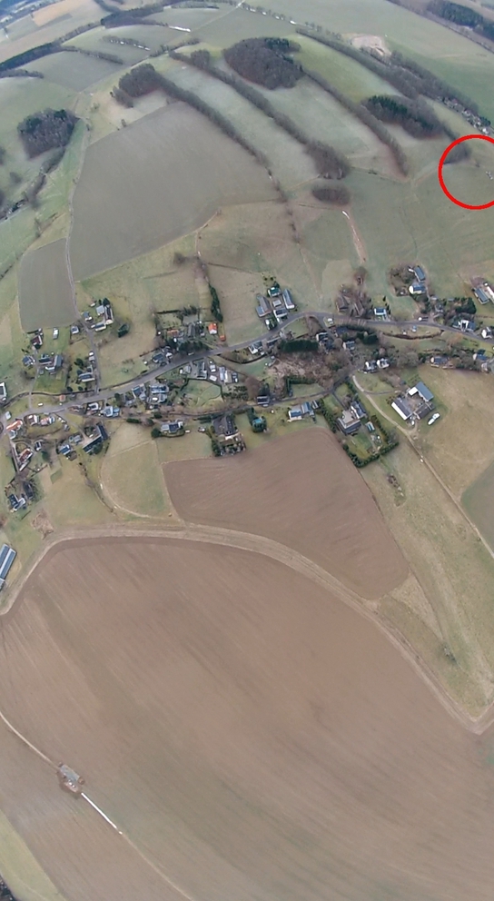
A quarter to noon (11:45) we got a first proof of live via an SMS position message. After a quick map look-up we realized it was a village in the Czech Republic, around 40mi (70km) far from our current position (air distance). It took around 2hours to get there by car, but fortunately the position was highly accurate. As the capsule finished it’s fall in the crown of a 100ft (30m) tall pine tree capture was impossible. So we came back a few days later with proper equipment. We received SMS positioning messages for more than 11 hours till the night.

SONY DSC 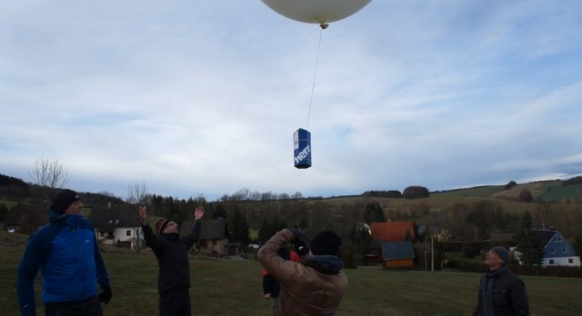

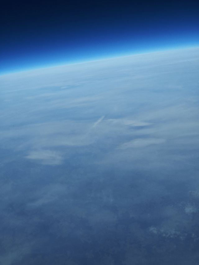
View from 20 km height 
Positions of the capsule
Time,Latitude, Longitude, Altitude
9:38:15AM, 50.838585, 13.382951, 478.90
10:04:52AM, 50.839, 13.395, 964.10
10:06:35AM, 50.842, 13.415, 1526.90
10:06:52AM, 50.845, 13.42, 1612.50
10:08:52AM, 50.846, 13.425, 2237.00
10:10:52AM, 50.847, 13.445, 2784.20
10:11:36AM, 50.848, 13.46, 2980.70
10:12:53AM, 50.849, 13.48, 3392.00
11:16:34AM, 50.801, 14.40, 3891.70
11:16:57AM, 50.802, 14.41, 3412.00
11:17:37AM, 50.803, 14.42, 2616.40
11:18:46AM, 50.804, 14.425, 1279.00
11:21:16AM, 50.805084, 14.429254, 435.30
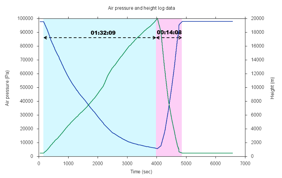
Air pressure and altitude
Even though GPS retrieves altitude information, above around 12,000ft (3991m) no valid values will be delivered by Smartphone inbuilt sensor. This is way below the official US Export Limits of 55,000ft (18.000m), yet we guess this limitation may also be related. Hence we used air pressure based altitude calculation.
The chart below illustrates the ratio between air pressure and altitude, based on the International Standard Atmosphere (ISA) model. It is important to keep in mind, that the used air pressure sensor BMP085 is only working reliably in environments >4.35psi (300hPa).
The altitude of the take-off site measured by GPS was 1500ft (478m), the one of the landing zone was 1400ft (435m). The values measured by the air pressure sensor were 300ft (100m) off, which is already corrected in the chart.
Based on the air pressure profile we have finally reached a maximum altitude of around 65,000ft (20km). Even though we missed our 100,000ft (30km) target level due to the extra weight we would call it a success, especially if look at this awesome set of pictures from the space.
Next time …
…we aiming for
- A 1lb (400g) lighter transport capsule, in order to reach the targeted altitude
- Less fill needed for the balloon
- Multiple connectors between shell and parachute in order to avoid the heavy rotation
- A better determination of the fall phase by the air pressure sensor instead of the acceleration sensor
